Dishank App Kannada Guide: How to Check Land Maps in India
Introduction
The Dishank App is an innovative mobile application developed by the Karnataka State Government to help citizens access digital land survey maps easily. This app is particularly useful for farmers, landowners, and real estate buyers who want to verify survey numbers, check land boundaries, and ensure there are no legal complications with the land.
In this detailed guide, you’ll learn how to use the Dishank App to check land maps in India, especially in Karnataka, and understand its benefits, features, and limitations.
What is Dishank App?
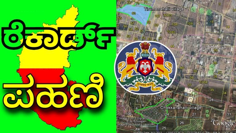
The Dishank App (Digitized State Land Records using Survey Settlement and Land Records) is a mobile app launched by the Department of Survey, Settlement, and Land Records (SSLR), Karnataka.
It provides:
- Access to revenue maps of surveyed lands.
- Survey number verification.
- Overlay of geo-referenced cadastral maps on satellite imagery.
- Mobile-based access for transparency and convenience.
Key Features of Dishank App
| Feature | Details |
|---|---|
| Survey Number Search | Locate land records using district, taluk, hobli, and survey number. |
| GPS Location Map | Detect land boundaries using your mobile’s GPS. |
| Integrated with Satellite View | Visualize plots and boundaries on Google Maps. |
| Free to Use | No charges for accessing land map data. |
| Multilingual Support | Supports Kannada and English. |
How to Download Dishank App
You can download Dishank App from the Google Play Store by following these steps:
- Open Google Play Store on your Android phone.
- Search for “Dishank – SSLR Karnataka”.
- Click on the app with the SSLR logo.
- Tap Install.
✅ Note: Dishank is currently available for Android only.
How to Use Dishank App to Check Land Maps in India
🔹 Step-by-Step Process:
- Open the Dishank App.
- Tap on “View RTC & Map” option.
- Select:
- District
- Taluk
- Hobli
- Village
- Enter your Survey Number.
- Tap Search.
- You will see the land parcel on the map with boundary details and nearby plots.
How to Check Land Ownership and Boundaries
Dishank allows users to:
- Verify boundaries of agricultural and non-agricultural land.
- Match survey number with actual land plot.
- Avoid land disputes by checking encroachments or overlaps.
However, Dishank maps are not legally valid for ownership confirmation. For official purposes, always cross-check with:
- RTC (Record of Rights)
- Pahani
- Encumbrance Certificate (EC)
Limitations of Dishank App
| Limitation | Description |
|---|---|
| Not for Legal Verification | Map data is for reference only, not a legal document. |
| Limited to Karnataka | Dishank is developed by Karnataka SSLR; other states may not support. |
| Requires Internet and GPS | Accurate usage depends on network and GPS signals. |
Benefits of Using Dishank App
- Prevent land fraud and misrepresentation.
- Identify land encroachments.
- Assist in land buying decisions.
- Great tool for real estate buyers, surveyors, and farmers.
- Supports digital India land record modernization.
Frequently Asked Questions (FAQs)
❓ Is the Dishank App available in other states?
Currently, Dishank is designed for Karnataka. Other states may have similar portals like:
- Bhoomi Karnataka
- Dharani Telangana
- Bhu Naksha Bihar
- MahaBhulekh Maharashtra
❓ Is Dishank data legally valid for sale or registration?
No. Use it for verification only. For legal documents, refer to RTC, EC, and Mutation Records.
❓ Can I check land maps by GPS location?
Yes. Dishank has a GPS-based map view to show your live location on cadastral maps.
✅ Download App link ✅
The Dishank App is a revolutionary tool that makes land map verification easier, more transparent, and accessible to every citizen in Karnataka. While it is not a substitute for legal documents, it plays a major role in avoiding land fraud, encroachment, and misinformation.
If you’re buying or selling land in Karnataka, always use Dishank App along with RTC, Mutation, and EC documents to ensure your land dealings are secure and verified.